Tropical warnings for Gulf, heavy rain expected
By JANET MCCONNAUGHEY - Associated Press | AP – 5 hrs ago
RELATED CONTENT
- This NOAA satellite image taken Thursday, September 01, 2011 at 01:45 PM EDT shows …
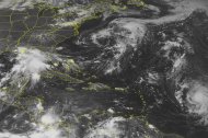
NEW ORLEANS (AP) — A slow-moving tropical system packing walloping rains is slogging its way to the Gulf coast, which could be drenched with up to 20 inches, leading Louisiana's governor to declare a state of emergency Thursday because of the threat of flash flooding.
Tropical storm warnings are out from Mississippi to Texas including New Orleans. The National Hurricane Center said the system that is now a depression in the Gulf of Mexico will dump 10 to 15 inches of rain over southern areas of Louisiana, Mississippi and Alabama through Sunday and as much as 20 inches in some spots. By Friday, it could become Tropical Storm Lee, the 12th named storm of the season.
Early forecasts were for landfall early Saturday afternoon in south-central Louisiana, though National Weather Service meteorologist Frank Revitte said it was too early for a firm time or location. The depression has sustained winds of 35 mph and was moving toward the northwest at only about 2 mph late Thursday.
"Wow. This could be a very heavy, prolific rain-maker," Revitte said.
According to a hurricane center chart, maximum sustained winds could reach 60 mph by Saturday, lower than hurricane strength of 74 mph.
As hurricane season is hitting its peak in the Atlantic, storm watchers were monitoring three disturbances. Besides the Gulf depression, Tropical Storm Katia (KAH'-tee-yah) is spinning in open waters. It weakened from a hurricane earlier in the day though forecasters say it will again grow stronger.
It was about 830 miles (1,336 kilometers) east of the Leeward Islands and moving west near 16 mph (26 kph) with maximum sustained winds Thursday evening near 70 mph (113 kph). It could become a major hurricane this weekend but forecasters said it's too early to tell if it will hit the U.S. It is expected to pass north of the Caribbean.
In yet another system, a slow-moving low pressure system about 500 miles (805 kilometers) south of Nova Scotia, Canada, stood a 40 percent chance in the next two days of becoming a tropical cyclone, the first step toward a tropical storm. It hadn't become any better organized throughout the day.
They all come on the heels of Hurricane Irene that brought destruction from North Carolina to New England last week.
In Louisiana, Gov. Bobby Jindal said he was concerned about the serious threat of flash flooding in his state, leading to his emergency action. After devastating Hurricane Katrina in 2005, nothing is taken for granted.
Craig Taffaro, president of coastal St. Bernard Parish, said some flood gates were being closed along bayous and residents were being warned to brace for heavy rain. Still, in a parish that was nearly wiped out six years ago by Katrina, Taffaro wasn't expecting a major event.
"We'd like the public to use this as a drill. Hopefully that's all it will be," he said early Thursday afternoon.
The Army Corps of Engineers, which operates major flood control structures at New Orleans, was monitoring developments but didn't plan on closing any flood control structures yet, spokesman Ricky Boyett said in an email. Alabama Gov. Robert Bentley ordered state emergency management and other agencies to be ready to respond if needed.
The heaviest rainfall was still in the Gulf of Mexico Thursday evening, with radar indicating 3 to 4 inches in some areas off the mouth of the Mississippi River, said NWS meteorologist Fred Zeigler.
Already, the storm has forced two major petroleum producers to remove crews from a handful of production platforms. Royal Dutch Shell and ExxonMobil said they would also cut off a small amount of production. Both moves affect only a fraction of production.
Louisiana needs rain — just not that much, that fast. All of both Texas and Louisiana have been suffering through drought. New Orleans, which was least affected by the drought, already was being pelted by sporadic rain. More of a problem is stubborn marsh fire that has blanketed the city with smoke, though the rain will help extinguish it.
"Sometimes you get what you ask for," New Orleans Mayor Mitch Landrieu said. "Unfortunately it looks like we're going to get more than we needed."
Louisiana's emergency allows Jindal to activate the National Guard if necessary and generally makes it easier for parishes and the state to prepare. It also lets parishes ask the state to repay money spent to prepare and fight floods, and lets the state track such expenses, said Jindal spokesman Kyle Plotkin.
"Now is the time for Louisianians to make sure they have a game plan for themselves and their families should this storm strengthen," Jindal said in a statement.
On Grand Isle, the state's only inhabited barrier island, people were keeping an eye on the storm that has already brought rain there.
"We're watching it — we're watching it closely," said June Brignac, owner of the Wateredge Beach Resort.
It's not as frightening as having a Category 2 or 3 hurricane bearing down, she said.
"But we're still concerned with all the rain that's coming in, causing possible flooding of the highway going out. If we don't leave, we may be trapped here until it's completely past," she said.
Katrina was the only storm to flood the suites in her motel, which is raised several feet from the ground, in the 20 years she has owned it.
Tropical storm warnings are out from Pascagoula, Miss., to the Texas state line.
It was still unclear where the system would head next, but it could bring much-needed relief to drought-plagued Texas.
Small craft warnings were issued from northwest Florida to Texas as seas of at least 1 to 2 feet above normal were in the forecasts. Winds are likely to push tides up to three feet above normal.