Jumat, 08 Januari 2010

Ice causes disruption

Jan 7, 2010

Ice causes disruption

The Met Office said severe weather warnings remained in place for eastern England, where up to 5 centimetres of snow is expected during the course of the day, with ice now the main problem as temperatures in most areas remain below freezing. -- PHOTO: REUTERS

LONDON - WIDESPREAD ice and sub-zero temperatures continued to cause disruption across Britain on Thursday, with the coldest weather in 30 years showing little sign of easing as forecasters predicted more snow.

The Met Office said severe weather warnings remained in place for eastern England, where up to 5 centimetres of snow is expected during the course of the day, with ice now the main problem as temperatures in most areas remain below freezing.

'Considering we had areas quite widely reporting 20 or 30 centimetres of snow over the last 48 hours, it is nowhere near as much as that but it is still severe weather because it is a case of ice combined with fresh accumulations of snow,' said Met Office forecaster Chris Bulmer. 'The ice problem is not really going to go away, it is going to be quite persistent over the next few days.'

He forecast further snowfall across eastern areas for the rest of the week, with possible heavy outbreaks across much of England and Wales on Sunday.

If the extreme weather continues until Saturday, it is estimated that the disruption could cost the UK economy up to 2 billion pounds (S$4 billion). The Federation of Small Businesses estimated about 10 per cent of workforce missed work on Tuesday and Wednesday because of problems getting to work.

Temperatures as low as -17 C were recorded overnight in Oxfordshire, with many inland areas remaining between -10 C and -15 C into Thursday. -- REUTERS

http://www.straitstimes.com/BreakingNews/World/Story/STIStory_474599.html

Energy use surges from cold

Jan 7, 2010

Energy use surges from cold

LONDON - ICY conditions have driven a surge in energy demand in heavily populated parts of the northern hemisphere but some countries are enjoying a relatively mild winter, data shows.

Severe weather, partly due to the El Nino weather phenomenon, has frozen parts of north-west Europe that usually escape the coldest winter temperatures, driving gas demand to records in Britain and straining French power systems. In China there are energy rations.

'I think the impression is that because north Asia is cold, and parts of North America and Europe are cold people have tended to get the impression that the whole of the northern hemisphere is cold,' said Mr Robin Thwaytes, a forecaster at the Met Office, Britain's official weather centre.

'But that isn't the case. Generally it evens itself out in that for every area that is cold there are some areas that are very warm.' The Met Office's latest chart of global temperature anomalies indicates that Alaska and much of Canada are warmer than the long-term average for the time of year.

Freezing temperatures and heavy snow at the start of January is a shock for those parts of north-west Europe - France and Britain - that are usually shielded from the coldest weather that typically affects central and eastern Europe in midwinter.

Britain, which uses gas to heat two thirds of its homes, and France which relies on electric heating are the hardest hit as the relatively mild south-westerly winds that usually blow in from the Atlantic are nudged out by Arctic winds from the north. The weather, which has driven UK gas prices up sharply this week, is expected to last for another two weeks, draining European gas supplies. -- REUTERS

http://www.straitstimes.com/BreakingNews/World/Story/STIStory_474471.html

Kamis, 07 Januari 2010

Frigid weather hits Midwest, -52 wind chill in ND

Frigid weather hits Midwest, -52 wind chill in ND


Britain blasted by heavy snowPlay VideoCBC.ca – Britain blasted by heavy snow
RELATED QUOTES
^DJI10,578.82+5.14
^GSPC1,137.59+0.45
^IXIC2,294.60-6.49
Vehicles travel in white out conditions caused by blowing snow on Interstate 80AP – Vehicles travel in white out conditions caused by blowing snow on Interstate 80 west of Omaha, Neb., …

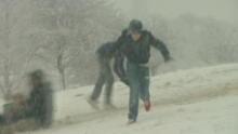
DES MOINES, Iowa – Snow was piled so high in Iowa that drivers couldn't see across intersections and a North Dakota snowblower repair shop was overwhelmed with business as heavy snow and wind chills as low as 52 below zero blasted much of the Midwest on Thursday.

Frigid weather also was gripping the South, where a rare cold snap was expected to bring snow and ice Thursday to states from South Carolina to Louisiana. Forecasters said wind chills could drop to near zero at night in some areas.

Dangerously cold wind chill levels hit the Midwest early Thursday including 52 below zero in northern North Dakota, negative 40 in parts of South Dakota and minus 27 in northeast Nebraska, according to theNational Weather Service. Equally disturbing chills were expected overnight Friday.

"Temperatures are going to be nose-diving," said Billy Williams, a weather service meteorologist in Sioux Falls, S.D. "Winds are slowing dropping off but will be more than compensated for."

An additional 10 inches of snow was expected in Iowa, already buried by more than 2 feet of snow in December, while up to 9 inches could fall in southeast North Dakota that forecasters warned would create hazardous zero-visibility driving conditions. Wind gusts of 30 miles per hour were expected in Illinois — along with a foot of snow — while large drifts were anticipated in Nebraska and Iowa.

Joe Dietrich said he had to turn away dozens of customers this week from his snowblower repair shop in Bismarck, N.D.

"My building is only so big and I can only take so many," Dietrich said.

The weather hasn't let up since sweeping into the eastern U.S. earlier this week. Five straight days of double-digit subzero low temperatures, including negative 19, were recorded by the National Weather Service office in Chanhassen, Minn., a Twin Cities suburb.

"It's brutally cold, definitely brutal," meteorologist Tony Zaleski said.

Several recent deaths have been blamed on the cold. An 88-year-old woman died of hypothermia in her unheated Chicago home, an Alzheimer's sufferer died after wandering into his yard in Nashville, Tenn., and a homeless man was found dead in a tent in South Carolina, authorities said. Kansas City police said a man involved in a multi-car pileup Wednesday died after jumping a barrier wall in the dark, apparently to avoid sliding cars, and falling about 80 feet.

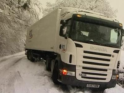
Slick roads were blamed for scores of accidents. In Indiana, a driver was reported killed in a crash with a school bus near Delphi on Thursday. In Iowa, a driver died Wednesday when slamming into the back of a semitrailer that had slowed for an accident near Des Moines.

In preparation for worsening conditions, more than 500 flights were grounded at Chicago's airports. The Chicago Department of Aviation reported more than 400 canceled flights at O'Hare International Airport and more than 100 canceled flights at Midway International Airport. Frost on planes' wings delayed seven early flights in Tampa, Fla.

Just one day into the 2010 legislative session, the Missouri Senate canceled its Thursday session because of weather. The House planned only a technical session, which allows bills to be processed without the attention of most lawmakers.

Freeze warnings covered nearly all of Florida with temperatures expected to drop into the 20s. Freezing iguanas were seen falling out of trees in Florida; experts say the cold-blooded reptiles become immobilized when the temperature falls into the 40s and they lose their grip on the tree.

Kentucky Gov. Steve Beshear declared a state of emergency in Perry County on Wednesday after water line breaks left areas without water.

Schools in parts of Nebraska, Minnesota, South Dakota, Oklahoma, Indiana, Kentucky, Mississippi, Alabama, Georgia canceled classes because of the weather. Major roads were closed in South Dakota, Minnesota, North Carolina and Virginia.

Salt had no effect on the Twin Cities' ice-rutted streets, and the deep snow left over from a Christmas storm has hardened into rock-hard blocks. The conditions helped business at Roger's Master Collision, an auto-body repair shop in Plymouth, Minn.

"A lot of people sliding on the ice, then hitting the snowbanks. They're frozen up pretty hard," said store manager Kirk Suchomel, estimating the shop is averaging 15 repair estimates a day. "I'm sure we're going to stay busy."

In Iowa, officials in Des Moines warned that a $3 million annual snow removal budget would likely be exhausted with this week's storm. Another 10 inches of snow was forecast overnight — on top of the more than 28 inches of snow that fell there in December.

Public Works Director Bill Stowe said the city would tap a $6 million road maintenance fund to cover snow clearing for the rest of the season. Snow that had been plowed into tall piles at intersections was set to be dumped into a lake.

"It can be a half-million dollar operation, depending on the amount of snow," Stowe said.

___

Associated Press writers Jeff Baenen in Minneapolis; James MacPherson in Bismarck, N.D; Nelson Lampe in Omaha, Neb.; and Erin Gartner in Chicago contributed to this report.

http://news.yahoo.com/s/ap/20100107/ap_on_bi_ge/us_winter_weather


Rabu, 06 Januari 2010

Government Forecaster To Give Earlier Storm Alerts

Government Forecaster To Give Earlier Storm Alerts

Reuters

Date: 06-Jan-10
Country: US
Author: Tom Brown

MIAMI - The U.S. National Hurricane Center, citing increases in population and infrastructure along the U.S. coastline, said on Tuesday it would warn 12 hours earlier of approaching storms during this year's hurricane season.

The Miami-based hurricane center said the earlier watches and warnings for tropical storms and hurricanes would give the public and operators of oil rig platforms in the Gulf of Mexico more time to prepare for adverse weather conditions.

"Tropical storm watches will be issued when tropical storm conditions are possible along the coast within 48 hours. Tropical storm warnings will be issued when those conditions are expected within 36 hours," the center said in a statement posted on the web site of National Oceanic and Atmospheric Administration.

"Similar increases in lead-time will apply to hurricane watches and warnings," the statement added. It said recent advancements in forecasting the tracks of storms and hurricanes now made earlier warnings possible.

The changes will go into effect in the 2010 hurricane season, which begins on May 15 in the Eastern Pacific and on June 1 for the Atlantic Basin, the hurricane center said.

A renowned team of researchers based at Colorado State University predicted last month that the 2010 Atlantic hurricane season would be "above-average" in activity and produce 11 to 16 tropical storms.

The storms would include six to eight hurricanes, the forecasters said, adding that three to five could become "major" hurricanes of Category 3 or higher on the Saffir-Simpson intensity scale.

(Editing by Pascal Fletcher and Jackie Frank)

© Thomson Reuters 2010 All rights reserved

http://planetark.org/enviro-news/item/56217

From fires to floods, to threat of cyclone

From fires to floods, to threat of cyclone

By Greg Ansley
4:00 AM Tuesday Jan 5, 2010
A burnt out vehicle in the West Australian town, Toodyay. Photo / Getty Images

A burnt out vehicle in the West Australian town, Toodyay. Photo / Getty Images

CANBERRA - Australia's wild weather ride continues, with floods in Queensland and New South Wales, extreme heat and bushfires in Western Australia and Tasmania, and a tropical cyclone forming off the Northern Territory.

And even as rain raised hopes of ending a decade-long drought, forecasters repeated warnings of a return to the fierce heat that last month pushed the fire danger to catastrophic levels across eastern states.

Total fire bans were declared over much of Western Australia yesterday - outlawing not only fires but even the movement of farm equipment across paddocks - as flames devoured land and buildings on Perth's northeastern fringe.

The bans covered Perth and the surrounding shires, the vast Kimberley, Pilbara and Gascoyne regions in the state's north, the coastal strip fanning out from Geraldton, north of Perth, and the farming expanses of the central wheatbelt.

With temperatures soaring into the high 30s yesterday, the fire danger was rated as severe to extreme.

Firefighters backed by five helicopters and two fire-bombing aircraft were late yesterday still battling a fire in the rugged hill country near the outer Perth suburb of Brigadoon, which started on Sunday afternoon.

Residents were evacuated as the fire, driven by hot, strong winds, raced through more than 200ha of bush and farmland, destroying several sheds before it was contained.

Three firefighters suffered smoke inhalation, and another injured a knee.

In Tasmania, bulldozers and helicopters joined the battle to control a fire raging in steep bushland on the island's north.

Reportedly lit by arsonists, the fire started near York Town on Sunday and has burned into Narawntapu National Park, driven by northwesterly winds towards the mining town of Beaconsfield.

No homes were under threat late yesterday, but residents of York Town, Beaconsfield, Beauty Pt and George Town were warned to prepare for possible spot fires from embers.

In northwestern New South Wales State Premier Kristina Keneally yesterday declared the area around Coonamble a disaster area as floodwaters failed to reach a peak that would have overwhelmed levees and inundated the now-isolated town.

More than 1000 people were evacuated as floodwaters rose on Sunday night.

The floods have also isolated about 400 farms and rural properties, some of which may which may be cut off for weeks.

Meanwhile, the cotton and wine town of Wee Waa to the northeast of Coonamble was late yesterday preparing for a similar fate as the Namoi River rose.

In Queensland, heavy rain threatened flooding in the central west after more than 100mm of rain was dumped on the Longreach area by storms since New Year's Eve.

The city of Longreach escaped inundation, but the Bureau of Meteorology has warned of possible floods later in the week at Windorah, southwest of Longreach, and has issued flood warnings for the Thomson, Barcoo and Landsborough rivers.

But for farmers, the rain has been welcome.

Although not yet broken, the drought that has gripped northern New South Wales for most of the new century has eased, with good prospects for summer crops and hopes for this year's main winter harvest.

In the far north, however, more trouble is brewing.

The meteorology centre said yesterday a low developing off the coast of the Northern Territory was expected to develop into a tropical cyclone this morning in the southern Joseph Bonaparte Gulf, west of Darwin.

The cyclone is expected to bring heavy rain and gales with gusts of up to 100km/h.

http://www.nzherald.co.nz/world/news/article.cfm?c_id=2&objectid=10618419&pnum=0

By Greg Ansley | Email Greg

Senin, 04 Januari 2010

Big quake strikes near Solomon Islands

Big quake strikes near Solomon Islands

AAPJanuary 4, 2010, 3:40 pm

A powerful 7.2 magnitude earthquake has struck near the Solomon Islands, triggering panic and causing some damage but no major tsunami, officials say.

Several houses collapsed, leaving a number of people homeless, and some tourists reportedly suffered minor injuries, disaster officials said, after a series of tremors shook the area on Monday.

The US Geological Survey said the epicentre of the biggest quake was about 103km from the earthquake-prone island town of Gizo, measured at a

depth of about 30km.

It was the largest of a swarm of tremors centred on the area, which began with a 6.5 magnitude quake early on Monday and was followed several hours later by aftershocks of magnitude 5.3 and 5.2 and 5.7.

On the tiny island of Rendova, near Gizo, several houses collapsed but there were no other reports of damage, Julian Makaa of the National Disaster

Management Office told AFP.

"The earthquake caused a small wave, and a few people suffered minor injuries as they ran away from the shore in panic," he said.

The Disaster Management Office had also received radio reports that some tourists received minor injuries on the conservation island of Tetepare and

there were houses destroyed at Marovo Lagoon, both near Rendova.

"A patrol boat will be sent to the area with water, food and tarpaulins as a precaution," Makaa said, adding residents on the outer islands have been warned "to remain alert for sea and tide fluctuations" as aftershocks continue.

About 10 people have reportedly been made homeless.

An 8.0-magnitude earthquake in the same area nearly three years ago killed 52 people, destroyed hundreds of homes and displaced thousands.

The Hawaii-based tsunami warning centre said the latest earthquake was powerful enough to have been destructive along coasts near the epicentre but

there was no wider threat.

"No tsunami threat exists for other coastal areas in the Pacific although some other areas may experience small, non-destructive, sea-level changes lasting up to several hours," the centre said in a bulletin.

Gizo, on Ghizo island, is the second largest town in the Solomon Islands archipelago with a population of around 6,000.

It is about 360km northwest of the capital Honiara, on the island of Guadalcanal, where residents said they felt shakes but there was no damage.

Honiara is 300km from where the nest of earthquakes was centred.

Geoscience Australia seismologist Clive Collins said the main quake, which was estimated at 7.0 magnitude by Australian seismologists, was probably about 80km from the nearest land.

Further south, in earthquake-prone New Zealand, tremors of 4.3 and 3.5 were recorded over the past 24 hours.

Like much of the Pacific, the Solomons regularly experiences large earthquakes and lies on the Pacific Ring of Fire which generates most of the

world's major tremors.

Gizo harbour lost most of it wharves and jetties in the 2007 quake and subsequent tsunami which was officially put at five metres high but with some

reports of a 10-metre-high wall of water.

On September 29 last year, a devastating tsunami swept along coasts in the Pacific islands of Samoa and Tonga, killing 186 people and wiping out entire

villages.

Villages and resorts in Samoa, American Samoa and northern Tonga were flattened by the giant waves generated by the massive earthquake, the strongest

in nearly a century.

Jumat, 01 Januari 2010

Banjir Bandang di Brasil, 18 Tewas

Banjir Bandang di Brasil, 18 Tewas
JUMAT, 1 JANUARI 2010 | 00:31 WIB

RIO DE JANEIRO, KOMPAS.com - Sedikitnya 18 orang tewas di Rio de Janeiro, Brasil setelah kota itu dilanda hujan lebat selama 24 jam dan mengakibatkan banjir dan tanah longsor.

Komandan Pertahanan Sipil, Sergio Simoes menjelaskan, di antara korban yang tewas itu terdapat lima anggota keluarga, termasuk satu bayi dan dua remaja. Di kawasan Baixada Fuminense, utara kota Rio, tiga sungai meluap, memaksa sekitar 200 orang untuk mengungsi dari rumah mereka.

Hujan yang terus mengguyur sepanjang hari mengancam perayaan tahun baru di Rio de Janeiro dan beberapa tempat lain. Hujan deras dan banjir telah mendorong para pejabat di kota Rio mengeluarkan peringatan terhadap kemungkinan tanah longsor, terutama di kawasan di utara, tengah dan barat kota. Pihak berwenang mendesak penduduk di daerah berisiko untuk pindah ke tempat yang aman.


TOF

Editor: tof

Sumber : AFP

http://internasional.kompas.com/read/xml/2010/01/01/00310694/banjir.bandang.di.brasil.18.tewas