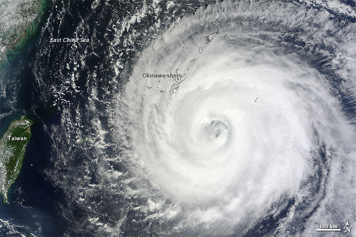
Typhoon Muifa
Muifa first formed as a tropical depression over the western Pacific Ocean on July 25, 2011. It strengthened to a tropical storm on July 28, and by the end of the month, it was a super typhoon. Muifa weakened slightly in early August, although it remained a typhoon.
The Moderate Resolution Imaging Spectroradiometer (MODIS) on NASA’s Terra satellite captured this natural-color image of Typhoon Muifa on August 4, 2011. The eye of the storm is east of Taiwan, and clouds overlap Okinawa.
The same day that MODIS captured this image, the U.S. Navy’s Joint Typhoon Warning Center (JTWC) reported that Muifa was located about 100 nautical miles (185 kilometers) south-southeast of Kadena Air Base in Japan. The storm had maximum sustained winds of 90 knots (170 kilometers per hour) with gusts up to 110 knots (200 kilometers per hour). The JTWC forecast that the storm would continue traveling toward the northwest, in the direction of Mainland China.
References
- Joint Typhoon Warning Center. (2011, August 4). Typhoon 11W (Muifa) Warning. Accessed August 4, 2011.
- Unisys. (2011, August 4). Muifa Tracking Information. Accessed August 4, 2011.
NASA image courtesy MODIS Rapid Response Team at NASA GSFC. Caption by Michon Scott.
- Instrument:
- Terra - MODIS
- http://earthobservatory.nasa.gov/NaturalHazards/view.php?id=51605&src=nhrss

Tidak ada komentar:
Posting Komentar