Montara (West Atlas) Blowout and Oil Spill, Western Australia, August 2009 |
Satellite and aerial images and maps showing the massive oil spill in the Timor Sea off Western Australia that resulted from a well blowout during drilling operations. On August 21, 2009, a well on the Montara offshore oil platform blew out as a new well was being drilled on the platform by the West Atlas mobile drilling rig. The rig and platform were immediately evacuated as oil, natural gas, and natural gas condensate spewed into the ocean from the uncontrolled well. This spill is expected to continue for at least 7 to 8 weeks, the time it will take to bring another rig into the area and drill a "relief well" that intercepts the damaged well several thousand feet below the seafloor.
The Montara platform, built and installed in 2008, and the West Atlas drilling rig, built in 2007, are modern, state-of-the-art offshore oil facilities.
Satellite images show that, by August 30, oil slicks and sheen had spread across over 2,500 square miles of ocean, in an area characterized by The Wilderness Society as a "marine life superhighway," a migration corridor for whales and turtles, dotted by coral reefs and marine biodiversity hotspots.
September 3: oil slicks and sheen extended across 5,800 square miles and had apparently expanded into Indonesian waters.
September 10: MODIS images taken from NASA's Terra and Aqua satellites about three hours apart show an area of patchy slicks and sheen about 3,600 square miles(=2,700 nautical square miles) in size, north of the Montara platform and extending well beyond Australia's territorial waters.
September 17: MODIS Terra and Aqua images show a convoluted area of discontinuous, patchy slicks and sheen mixed with open water extending across7,530 square miles (=5,680 nautical square miles) mostly north of the Montara platform. A large patch of slick is within 14.5 miles (12.5 nautical miles) of Cartier Island Marine Reserve.
September 24: strong winds moved into the area between the time the Terra satellite and the Aqua satellite passed overhead, increasing from 10 kts to 18 kts. The Terra image shows an area of 9,870 square miles (=7,455 square nautical miles) of patchy, discontinuous slick; this was reduced to 3,940 square miles (=2,976 square nautical miles) on the Aqua image five hours later. The higher wind speed for the Aqua image is either obscuring, or has actually dissipated, the thinnest portions of the slick. That would be good news, since the slicks on the Terra image appear to make contact with Cartier Island.
October 21: two months after the spill began, three attempts to kill the leaking well have failed. MODIS / Terra imagery shows the slicks extending across 2,624 square miles (1,982 nautical square miles) and approaching within 35 miles (30 natical miles) of the Kimberley coast. For several days the slicks have been transported toward the Australian coast, south-southeast from the Montara platform.
October 27: a MODIS / Aqua satellite image shows an airborne plume blowing southeast from the Montara platform - possibly smog formed by the natural gas and vaporized natural gas condensate that is being released into the air from the damaged well.
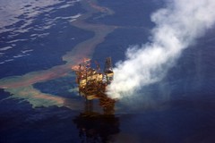
November 1: the fifth attempt to intercept the out-of-control well succeeded, but during initial operations to kill the well, the Montara platform and West Atlas drill rig caught fire. MODIS images taken on November 2 show a 100-mile-long plume of smoke blowing west-southwest from the platform location, and residual patches of oil and sheen within 27 miles of islands along the Australian coast.
November 3: the fire is extinguished and the spill has been stopped. The next step is to fill the failed well with a permanent cement plug, an operation complicated by damage to the Montara platform. The $250M West Atlas drill rig is apparently a total loss. The Australian government has launched an investigation.
December 16: Tropical cyclone Laurence is moving through the Timor Sea as a powerful Category 5 storm. Workers on the fire-damaged Montara platform have been evacuated. On December 15, the eye was 18 miles in diameter, and the storm was moving southwest at nearly 15 miles per hour, passing about 130 miles southeast of the Montara platform.
January 21, 2010: The eye of tropical cyclone Magda, a Category 2 storm, is located about 186 km southwest of the Montara platform, and the storm is moving to the south.
February 8, 2010: We've added a sequence of maps showing the cumulative ocean surface impacted by oil slicks and sheen, based on aanlysis of the MODIS imagery; and a map of the cumulative slicks with the state of Virginia superimposed for scale. We calculate that slightly over 22,000 square miles was cumulatively impacted by oil, an area about the size of West Virginia.
April 12, 2010: In light of the Obama administration's recent announcement to allow drilling to expand along much of the East Coast, we thought it would be interesting to see what a Montara-sized oil spill might look like if happened from well in federal waters, 60 miles off the coast of Delaware. It impacts the entire coastline of New Jersey, from Cape May to Sandy Hook, and we've only shown about 18,000 square miles of the 22,000 square mile cumulative Montara footprint.
http://www.flickr.com/photos/skytruth/sets/72157622226354812/detail/
http://www.flickr.com/photos/skytruth/sets/72157622226354812/detail/?page=2
http://www.flickr.com/photos/skytruth/sets/72157622226354812/detail/?page=3
http://www.flickr.com/photos/skytruth/sets/72157622226354812/157622226354812/detail/
Tidak ada komentar:
Posting Komentar